This map will detail any potential evacuations in Mission Viejo
To stay on top of potential evacuation zones due to the Silverado Fire, you can view the City of Mission Viejo's evacuation maps (zones 1-25) here. You can also search your address at this link. Simply enter your address and it will tell you what zone you are in.
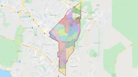
Currently, an evacuation "warning" is issued for Zone 1 in Mission Viejo - Painted Trails and Sky Ridge Communities north of the 241 Toll Road (El Toro Rd to the north Marguerite Pkwy to the west Upper Oso reservoir to the east Los Alisos Blvd to the south).
The City will continue to provide information as it's available.
Comments
It would be nice to show a…
It would be nice to show a map of where all the Mission Viejo evacuation zones are located.
The zone locater is not…
The zone locater is not working. How can we just be told what zone we are in so when alerts are issued we know?
The City's evacuation map…
The City's evacuation map has a process to determine the number of your evacuation zone. Please plan ahead to take this extra step now for awareness of your circumstances: https://missionviejo.geoviewer.io/
I see nothing on this map…
I see nothing on this map that indicates evacuation zone number. It is glitchy and cumbersome.
In addition to AlertOC, I…
In addition to AlertOC, I just signed up to this Nixle Alerts system - does the City have to join? I learned of this alert system from a City of Lake Forest post:
How do I sign up for Nixle alerts?
Simply text any zip code to 888777 and receive real-time alerts and advisories directly from your local police department and other local agencies. There is no charge for registering, but standard text messaging rates associated with your mobile phone service will apply.
While your PDF maps are very…
While your PDF maps are very useful (thank you), an overall map of Mission Viejo with zones indicated would be helpful. Or better, a map of the city indicating the zones that have been given an evacuation warning or a mandatory evacuation notice - like the one for Lake Forest:
https://lakeforestca.gov/1041/Silverado-Fire---Live-Updates
That's a very useful and helpful map.
We would like to thank the…
We would like to thank the community for your patience with the fire zones map. The developer reported that overwhelming demand crashed their server. The map has since been moved to a larger server and is up and running again. You can also see individual maps for zones 1-25 so there are two options now:
Individual Maps
https://cityofmissionviejo.org/sites/default/files/All%20Zones.pdf.
Interactive Map
https://cityofmissionviejo.org/news/map-will-detail-any-potential-evacu…
When I go to the page that…
When I go to the page that says at the top "This map will detail any potential evacuations in Mission Viejo" it says that I am in Zone MV 06. However, when I use the tool that allows me to enter my address, it tells me that my address is in Zone MV 15. From looking at the map, it is clear that my address is really in Zone MV 15. So the evacuation zone that was provided to me automatically was incorrect. I imagine that I am not the only resident who is being given an incorrect evacuation zone.
The MV website says only…
The MV website says only Zone 1 has been given a warning. The Fire Map shows a small section of Zone 2 is in the voluntary evac area. Please add Zone 2.
I live in Evacuation Zone 7,…
I live in Evacuation Zone 7, what is our assigned evacuation location(s)? Thanks. Steve
Your evacuation zones do not…
Your evacuation zones do not match CalFire’s evacuation zones. Extremely dangerous as the north part of Mission Viejo Zone 2 is currently under voluntary evacuation according to their far more reputable evacuation map. Fix it. It’s extremely negligent to leave it like this as people who follow your pictures could potentially put their lives in danger if they do not evacuate in time.
Very disappointed that our city put this out without any coordination with the county and state fire authorities or with any interactive, up-to-date map. Embarrassed that we have a far worse response then other cities during this natural disaster, too. We need better than this, it’s 2020.
What does MV 03 mean? At…
What does MV 03 mean? At what number do you need to evucate?
Thanks,
Pam
Wish MV's website was as…
Wish MV's website was as easy to search for fire information as the City of Lake Forest!!!
A number of people have…
A number of people have complained that the City's maps did not match the County's. The County's map had an anomaly and has been corrected. The City's map remains accurate and both maps now show the same area for Zone 1. Zone 1 remains the only zone in evacuation warning status this afternoon (10/27/20 at 3:30 p.m.)
I retired from tech, my hat…
I retired from tech, my hat's off to the MV tech department!! I am very sympathetic to your stress right now. Thank you so much for what you are doing. This is more stress than I ever experienced in my 35-year tech career. Hang in there guys, a family of citizens is forever grateful for your work!
Great Maps & Evacuation Plan…
Great Maps & Evacuation Plan, Good Job MV!
(However Developers need to be told to install more evacuation routes to highways within subdivisions. As I see it some residents are effectively trapped in their own subdivisions )
As a Grandma with kids in Zone 3 monitoring the Silverado from another state perhaps an update around 5am?
Good Wishes
DR
Please fix the automatic…
Please fix the automatic assigned zone number. I have the same problem . Otherwise, appreciate the efforts. We are in this together .
Big Fail on MV's part. If…
Big Fail on MV's part. If the servers were down, why didn't you post that on your website and offer alternatives? The wildfires are only going to get worse. You got lucky this time.
I received the following…
I received the following updates from the City of Lake Forest via its Nixle Alert system:
1:59 A.M.
Advisory: Silverado Fire Update
Dear Nixle User,
Cal Fire reports the Silverado Fire is at 13,354 acres with 5 percent containment. Cal Fire has taken the lead on managing the fire and will provide updates at 7 a.m. and 7 p.m. daily.
No structures have been damaged. Mandatory evacuations remain in place for Baker Ranch, Foothill Ranch, and Portola Hills. The City expects an update at first light.
8:19 A.M.
Advisory: Silverado Fire Evacuation Update Expected Today
Dear Nixle User,
Cal Fire and OC Fire Authority report the Silverado Fire is now at 13,354 acres with 25 percent containment. The City has no new information about evacuations, which remain in place. We expect an update about noon, and will post them here and on a recorded hotline at (949) 461-3536
The fire has moved further…
Why is MV 1 still under voluntary evacuation warning? The fire has moved further NW from our area. There are areas much closer to the fire where the evacuation warnings have been lifted. Can you please provide an update? Thank you.
Is there still an evacuation…
Is there still an evacuation warning in effect in zone 1? The county's website is showing that area as cleared.
The evacuation warning was…
The evacuation warning was lifted this afternoon: https://cityofmissionviejo.org/news/evacuation-warning-lifted-mission-v….
This page still comes up…
This page still comes up from clicking "Fire Alert" on the front page of the MV website. Maybe that should go to the latest news instead?
It's a little confusing because this page is out of date but it's very easy to get here.
Thanks!